Recent heavy rain and high river flows that reached record highs in some areas have provided a welcome boost to aquifer levels across the District.
One long-running groundwater level Motueka Gravel Aquifer monitoring site in the Lower Moutere area recorded its highest groundwater level on record (data starts in 1978). It exceeded its previous maximum (in August 1990) by 450mm during late June.
Groundwater is water found beneath the ground surface. Groundwater levels are determined by the balance between rainfall, surface water infiltration, and the underlying geology.
Many of the shallow gravel aquifers in the river valleys and alluvial plains – which are linked to rivers and direct rainfall for their groundwater supply – will recharge at a quicker rate.
Other aquifers, like the deep Moutere Aquifers, which are only recharged by rainfall, work on a slower basis due to the less permeable geology, which only allows a portion of rainfall to seep deeper. Most of the rainfall in these areas runs off quickly via rivers and streams.
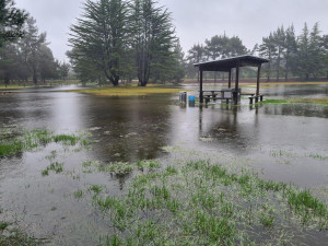
High water tables can also cause the groundwater to flood, especially in lower-lying areas.
Groundwater levels will recede slowly over time as the ground dries up and groundwater flows out to sea and back into surface water such as rivers or streams. During drier periods, groundwater is a major contributor to river/stream flows.
In coastal or low-lying areas, rising sea levels and more intense rainfall are pushing groundwater levels higher. Anyone who has visited the mini lakes of Moturoa / Rabbit Island (pictured) lately will have seen this in action.